Tag: Nomenclature Cards
Showing all 2 resultsSorted by latest
-
 $2.00Add to Cart
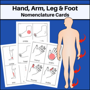
Hand, Arm & Food – Human Anatomy Nomenclature Cards – This resource will help students learn and study the location of the following parts of body parts: Hand (palm, thumb, index, middle, ring, pinky, fingernails, wrist; Arm (elbow, forearm, wrist, upper arm, shoulder); Foot (sole, ball, toes, ankle, toenails, heel); Leg (thigh, knee, calf, shin, kneecap, hip).
-
$6.00Add to Cart
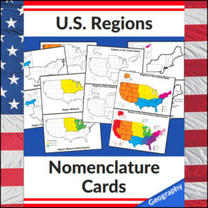
Mastering the map has never been more visual! This set of 20 professional nomenclature cards is the perfect foundational tool for any U.S. geography unit. Based on the 4 regions as defined by the U.S. Census Bureau (Northeast, Midwest, South, and West), these cards provide a clear, structured way for students to visualize how the United States is organized.
From full-color coded keys to black-and-white standalone regional maps, this versatile set helps students transition from “the big picture” to specific regional details with ease.
🧠 The “How” and “Why” (Educational Benefits)
Why use nomenclature cards for geography? It’s all about spatial recognition and scaffolded learning:
- Visual Discrimination: By seeing a region highlighted in color against a grayscale map of the whole U.S., students naturally learn exactly where that region sits in relation to the rest of the country. 📍
- Scaffolded Difficulty: Start with the cards that include state names for guided learning, then transition to the name-free cards to challenge their memory. 🎓
- Standards-Aligned: Because these follow the U.S. Census Bureau divisions, you can be confident your students are learning the most widely accepted geographic classifications used in social studies. ✅
- Versatility: The mix of color and black-and-white versions allows for high-impact visual aids or budget-friendly, student-ready worksheets.
🛠️ Ways to Use These
- Geography Centers: Laminate the color cards and use them as a “match the region” game or sorting activity. 🧩
- Interactive Notebooks: Print the black-and-white versions for students to color in, label, and glue into their social studies journals. 📓
- Flashcard Drills: Use the cards to quiz students on state locations within specific regions (e.g., “Which states are in the Midwest?”). ⚡
- Display: Create a stunning “Geography Wall” using the full-color coded keys as a reference point for students during independent work. 🖼️
🚀 Help Your Students Find Their Way!
Equip your geography explorers with the visual tools they need to master U.S. Geography. Add these US Regions Nomenclature Cards to your teaching toolkit today and watch their map-reading confidence soar! 🌟
UPGRADE and get this BUDNLE: Regions of the U.S.A. | Geography Bundle