Category: Classroom Helps
Showing 1–20 of 21 resultsSorted by latest
-
 $2.00Add to Cart
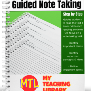
Help students dive into new text and get the most from their reading by using Guided Note Taking.
This resource will walk students through a process of reading the text 3 times.
Each time they read, they will be asked to perform a specific task:
- – The first time they read, students are asked to identify and write down important terms.
- – During the second reading, they are asked to identify important concepts and ideas. For this task, they are given lined paper as well as a page for illustrations.
- – During the third reading, students are asked to define the important terms they identified during their first reading.
This product can be used for any subject and used again and again!
-
$2.00Add to Cart
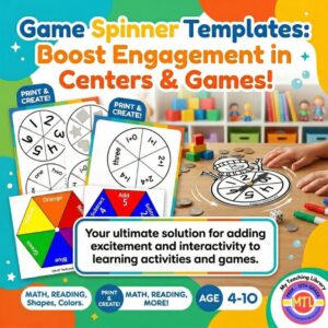
Tired of searching for engaging, versatile tools to liven up your learning games? This printable game spinners resource is your ultimate solution for adding excitement and interactivity to any learning activity and games.
✨ What’s Included:
- 10 unique spinner templates designed for flexible use.
- Templates featuring basic numbers 1-6 in both numerals and words.
- Templates incorporating addition and subtraction challenges.
- Templates for identifying shapes and colors.
📚 Learning Objectives
- Students will be able to accurately identify numbers, shapes, and colors.
- Students will practice basic addition and subtraction skills.
- Students will engage in cooperative play and turn-taking through games.
-
$3.00Add to Cart
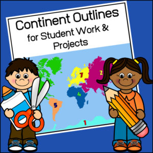
This resource, Continent Outlines for Student Work and Projects, contains 14 pages of continent outlines (7 labeled, 7 unlabeled). This is not clipart but ready to use outlines, just print and give to students to use however they need to!
-
$3.50Add to Cart
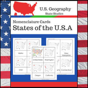
Students learning about individual U.S. States? This resource, Geography Nomenclature Cards – States of the U.S.A., will be a great addition to your classroom.
Includes two sets of State nomenclature cards PLUS pocket templates. Set one is best used with the pockets (see included photo). Set two can be used with or without the pockets. Students can use either (both) sets to study the location of each state. Students can also test themselves to see if they know the name of each state when shown the location!
-
$1.00Add to Cart
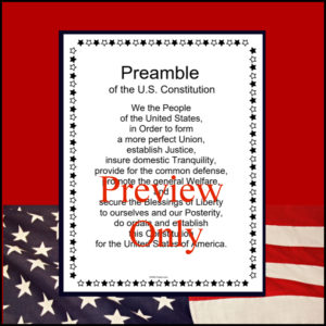
This resource is a one page b/w poster of the Preamble of the United States Constitution.
-
$3.00Add to Cart
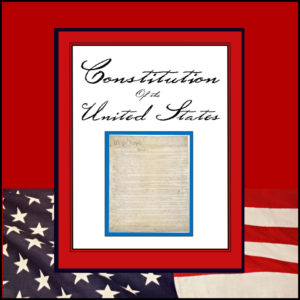
This resource is a complete transcript of the United States Constitution including amendments 1 – 27. It is b/w (print and go) and in 23 pages in length.
-
$1.00Add to Cart
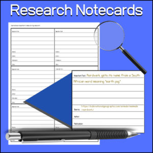
A student tool to aid them in research. Students will use to keep notes while researching. Each card has a place to record:
- -Important fact
- -Source
- -Author
- -Publication
- -Other
Can be used for any subject or research project.
-
$1.50Add to Cart
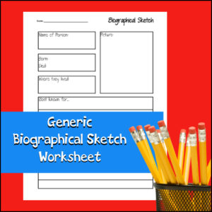
Students can use this worksheet again and again to record short biographies on any person for any subject. This worksheet can be used alone or as part of a larger report or notebooking project. Students can report on inventors, scientists, explorers, mathematicians, musicians, famous Americans, etc!
-
$6.00Add to Cart
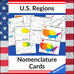
Mastering the map has never been more visual! This set of 20 professional nomenclature cards is the perfect foundational tool for any U.S. geography unit. Based on the 4 regions as defined by the U.S. Census Bureau (Northeast, Midwest, South, and West), these cards provide a clear, structured way for students to visualize how the United States is organized.
From full-color coded keys to black-and-white standalone regional maps, this versatile set helps students transition from “the big picture” to specific regional details with ease.
🧠 The “How” and “Why” (Educational Benefits)
Why use nomenclature cards for geography? It’s all about spatial recognition and scaffolded learning:
- Visual Discrimination: By seeing a region highlighted in color against a grayscale map of the whole U.S., students naturally learn exactly where that region sits in relation to the rest of the country. 📍
- Scaffolded Difficulty: Start with the cards that include state names for guided learning, then transition to the name-free cards to challenge their memory. 🎓
- Standards-Aligned: Because these follow the U.S. Census Bureau divisions, you can be confident your students are learning the most widely accepted geographic classifications used in social studies. ✅
- Versatility: The mix of color and black-and-white versions allows for high-impact visual aids or budget-friendly, student-ready worksheets.
🛠️ Ways to Use These
- Geography Centers: Laminate the color cards and use them as a “match the region” game or sorting activity. 🧩
- Interactive Notebooks: Print the black-and-white versions for students to color in, label, and glue into their social studies journals. 📓
- Flashcard Drills: Use the cards to quiz students on state locations within specific regions (e.g., “Which states are in the Midwest?”). ⚡
- Display: Create a stunning “Geography Wall” using the full-color coded keys as a reference point for students during independent work. 🖼️
🚀 Help Your Students Find Their Way!
Equip your geography explorers with the visual tools they need to master U.S. Geography. Add these US Regions Nomenclature Cards to your teaching toolkit today and watch their map-reading confidence soar! 🌟
UPGRADE and get this BUDNLE: Regions of the U.S.A. | Geography Bundle
-
$2.50Add to Cart
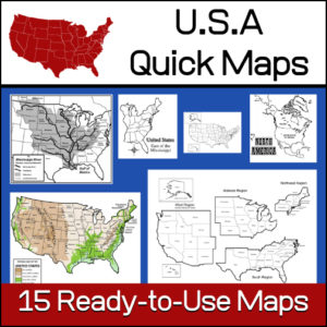
15 ready-to-use maps of the United States. Use for class projects, to create lessons or presentations.
Non-commercial use only.Includes:
– 2 maps showing the US within North America
– US maps (with states names and unnamed)
– US regional maps (with states names and unnamed)
– US east of the Mississippi (with states names and unnamed)
– US west of the Mississippi (with states names and unnamed)
– Physical Maps of the US (color and b/w)
– The Mississippi River with tributaries (states named) -
$5.00Add to Cart
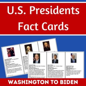
Studying the U.S. Presidents, U.S. History, or U.S. Government? These U.S. Presidents Fact Cards are perfect for students wanting to learn more about each president, from Washington to Biden. Also includes 2 blank templates to use for future presidents.
Three info cards per page, each approximately 5″ x 3″. To use year after year, laminate the cards after you print and cut out.
Each card includes:
- Photo and Name
- Date of Birth (some include date of death)
- Party affiliation
- Age when inaugurated
- Term (years of service)
- A famous fact(s)
-
$1.50Add to Cart
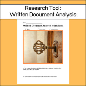
When doing research, students will find many written documents that could be appropriate to draw from. However, it is important to analyze each. Why? Analyzing historical documents requires students to identify the purpose, message, and audience of a text. This worksheets is a graphic organizer that will guide students through the analysis of these documents.
-
$2.00Add to Cart
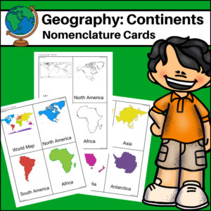
This resource, Continents – World Geography Nomenclature Cards, will help your students learn the shape of each of the seven continents!
Includes 2 sets:
– Color set for a Social Studies / Geography Center or for use on an interactive bulletin board
– B/W set to give each student there own ‘flash’ nomenclature cards -
$1.00Add to Cart
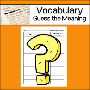
One strategy to help students learn unfamiliar vocabulary is called: Guess the meaning. This ready-to-use worksheet has been designed to be used again and again, throughout the school year as students encounter new vocabulary words. Students will write each ‘new‘ word, what they ‘think’ it means and then after looking up the word in a dictionary, they will write an actual definition.
-
$3.00Add to Cart
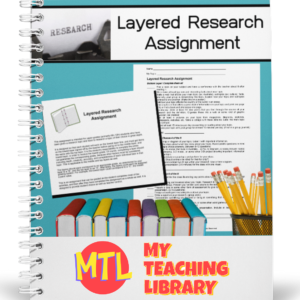
This layered research assignment gives students the opportunity to delve deeply into a topic and give students a variety of tasks from which to choose, all designed to guide and build a meaningful learning experience. Also, when using this layered approach, students will move through Bloom’s Taxonomy of knowledge, comprehension, application, analysis, synthesis and evaluation. (See below description for more details.)
Closely related resources:
-
$3.00Add to Cart
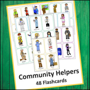
There is a flash card with an adorable illustration of each of 48 community helpers in this product. (See description below for a list)
-
$3.00Add to Cart
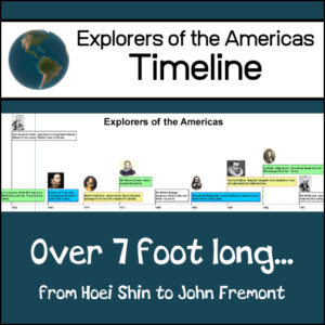
This resource will create a classroom wall timeline (over 7′ long) showing famous explorers of the Americas! The timeline begins with Hoie Shin: a Chinese monk who explored the west coast of Mexico in 499 and ends with John Fremont: nicknamed the “Pathfinder” who explored the American West in 1838. (Examples of other explorers included: Leif Ericksson, Columbus, Cabot, Cortez, Coronado, Daniel Boone, John Cook, Davy Crockett and others)
-
$8.50Add to Cart
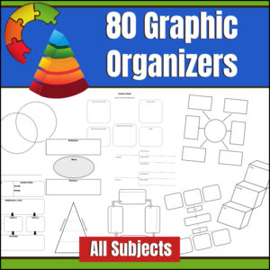
A graphic organizer, also known as knowledge map, concept map, story map, cognitive organizer, advance organizer, or concept diagram, is a communication tool that uses visual symbols to express knowledge, concepts, thoughts, or ideas, and the relationships between them. This resource gives you 80 different graphic organizers and can be used across the curriculum!
Here is a comment from a customer…
Karen E. said: “OK, at first I thought “Really? I’m going to pay for graphic organizers that I can probably find for free with some searching, etc?” Well, now I am so glad that I did. So good to have organizers available quickly BUT also several of them have variations which is helpful for “seeing” how to use them in my content area. Good value.“ -
$5.00Add to Cart
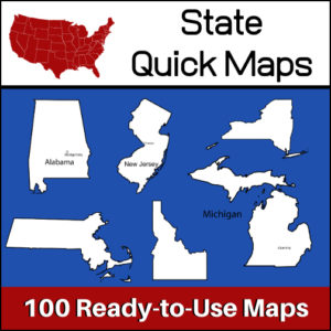
100 U.S. State outline maps – 2 maps for each state on one page:
- – Completely blank outline map
- – An outline with the state name and capital
Maps can be used for projects, bulletin boards, lesson plans and presentations.
Non-commercial use only. -
$2.00Add to Cart
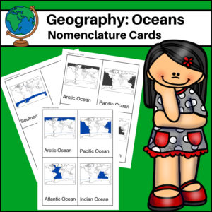
This resource, Oceans – World Geography Nomenclature Cards, will help your students learn the names and locations of the world’s 5 major oceans: Arctic, Atlantic, Pacific, Indian and Southern.