Category: Classroom Helps
Showing all 20 resultsSorted by latest
-
Sale!
 Original price was: $11.25.$9.00Current price is: $9.00.Add to Cart
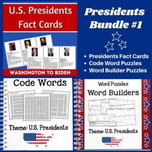
Studying the U.S. Presidents? Check out this BUNDLE! It includes three products and when you bundle, you save!
-
 $2.00Add to Cart
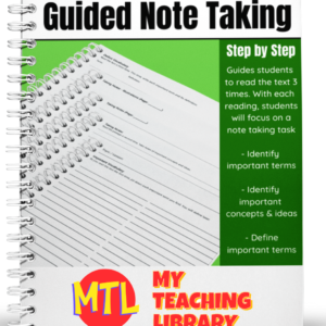
Help students dive into new text and get the most from their reading by using Guided Note Taking.
This resource will walk students through a process of reading the text 3 times.
Each time they read, they will be asked to perform a specific task:
- – The first time they read, students are asked to identify and write down important terms.
- – During the second reading, they are asked to identify important concepts and ideas. For this task, they are given lined paper as well as a page for illustrations.
- – During the third reading, students are asked to define the important terms they identified during their first reading.
This product can be used for any subject and used again and again!
-
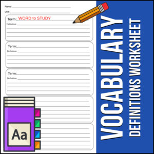
 $1.00Add to Cart
Easy to use, just print and go…This Vocabulary Terms Definitions Worksheet resource provides a template for students to use time and time again with any subject for any vocabulary that you are asking them to study.
Each page provides space for 5 words. Students will write each terms to be studied and a definition. (Option: If appropriate to the lesson(s), you can assign students to write synonyms or antonyms on the last line as there is plenty of space to do that!)
Use for Language Arts, Science, Social Studies, Math – ANY SUBJECT!
-
$3.50Add to Cart
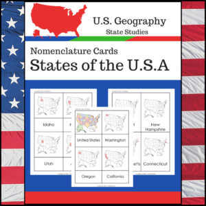
Students learning about individual U.S. States? This resource, Geography Nomenclature Cards – States of the U.S.A., will be a great addition to your classroom.
Includes two sets of State nomenclature cards PLUS pocket templates. Set one is best used with the pockets (see included photo). Set two can be used with or without the pockets. Students can use either (both) sets to study the location of each state. Students can also test themselves to see if they know the name of each state when shown the location!
-
 $8.00Add to Cart
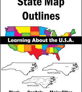
150 maps included in this download!
Each state has 3 pages / maps:
* Outline of the state
* Map showing the capital
* Map showing the major cities -
$3.00Add to Cart
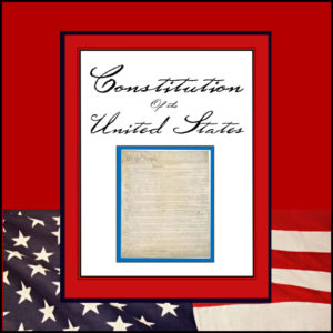
This resource is a complete transcript of the United States Constitution including amendments 1 – 27. It is b/w (print and go) and in 23 pages in length.
-
$8.75Add to Cart
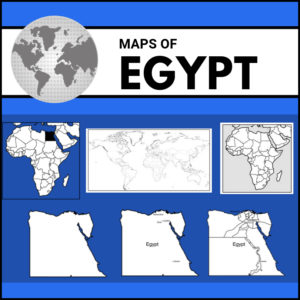
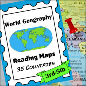
A comprehensive map-reading resource designed to help students develop essential navigation and analytical skills by focusing on 35 different countries.
Key Features:
-
Country-Specific Focus: For each country, students are given a map and asked specific questions that will require them to read the map to answer. (Questions may be things such as the location of the capital, naming rivers that are within or border the country, mountain ranges within the country, what nations border the country, etc.)
-
Critical Thinking Exercises: The worksheets go beyond simple identification, prompting students to solve navigation problems, determine cardinal directions, and estimate distances between major cities.
-
Integrated Learning: The resource connects physical geography with logical reasoning, helping students understand how environmental features like mountain ranges and bodies of water shape national landscapes and travel routes.
-
Ready-to-Use Answer Keys: The included answer keys make this an efficient tool for independent study, homeschooling, or classroom assessment.
Countries included: Algeria. Antarctica. Argentina. Australia. Bolivia. Brazil. Canada. Chile. China. Colombia. Ecuador. Egypt. Ethiopia. France. Ghana. Greece. Spain/Portugal. India. Iran. Iraq. Ireland. Italy, Japan, Kenya, Liberia, Libya, Madagascar, Mexico, Morocco, Nigeria, Peru, Russia, Saudi Arabia, South Africa, Uganda
This resource is an ideal addition to any social studies program, providing the structure needed for students to build confidence in reading maps and understanding global geography.
-
-
$6.00Add to Cart
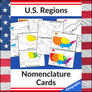
Mastering the map has never been more visual! This set of 20 professional nomenclature cards is the perfect foundational tool for any U.S. geography unit. Based on the 4 regions as defined by the U.S. Census Bureau (Northeast, Midwest, South, and West), these cards provide a clear, structured way for students to visualize how the United States is organized.
From full-color coded keys to black-and-white standalone regional maps, this versatile set helps students transition from “the big picture” to specific regional details with ease.
🧠 The “How” and “Why” (Educational Benefits)
Why use nomenclature cards for geography? It’s all about spatial recognition and scaffolded learning:
- Visual Discrimination: By seeing a region highlighted in color against a grayscale map of the whole U.S., students naturally learn exactly where that region sits in relation to the rest of the country. 📍
- Scaffolded Difficulty: Start with the cards that include state names for guided learning, then transition to the name-free cards to challenge their memory. 🎓
- Standards-Aligned: Because these follow the U.S. Census Bureau divisions, you can be confident your students are learning the most widely accepted geographic classifications used in social studies. ✅
- Versatility: The mix of color and black-and-white versions allows for high-impact visual aids or budget-friendly, student-ready worksheets.
🛠️ Ways to Use These
- Geography Centers: Laminate the color cards and use them as a “match the region” game or sorting activity. 🧩
- Interactive Notebooks: Print the black-and-white versions for students to color in, label, and glue into their social studies journals. 📓
- Flashcard Drills: Use the cards to quiz students on state locations within specific regions (e.g., “Which states are in the Midwest?”). ⚡
- Display: Create a stunning “Geography Wall” using the full-color coded keys as a reference point for students during independent work. 🖼️
🚀 Help Your Students Find Their Way!
Equip your geography explorers with the visual tools they need to master U.S. Geography. Add these US Regions Nomenclature Cards to your teaching toolkit today and watch their map-reading confidence soar! 🌟
UPGRADE and get this BUDNLE: Regions of the U.S.A. | Geography Bundle
-
$2.50Add to Cart
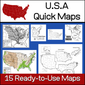
15 ready-to-use maps of the United States. Use for class projects, to create lessons or presentations.
Non-commercial use only.Includes:
– 2 maps showing the US within North America
– US maps (with states names and unnamed)
– US regional maps (with states names and unnamed)
– US east of the Mississippi (with states names and unnamed)
– US west of the Mississippi (with states names and unnamed)
– Physical Maps of the US (color and b/w)
– The Mississippi River with tributaries (states named) -
$5.00Add to Cart
Studying the U.S. Presidents, U.S. History, or U.S. Government? These U.S. Presidents Fact Cards are perfect for students wanting to learn more about each president, from Washington to Biden. Also includes 2 blank templates to use for future presidents.
Three info cards per page, each approximately 5″ x 3″. To use year after year, laminate the cards after you print and cut out.
Each card includes:
- Photo and Name
- Date of Birth (some include date of death)
- Party affiliation
- Age when inaugurated
- Term (years of service)
- A famous fact(s)
-
$1.00Add to Cart
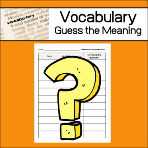
One strategy to help students learn unfamiliar vocabulary is called: Guess the meaning. This ready-to-use worksheet has been designed to be used again and again, throughout the school year as students encounter new vocabulary words. Students will write each ‘new‘ word, what they ‘think’ it means and then after looking up the word in a dictionary, they will write an actual definition.
-
$2.00Add to Cart
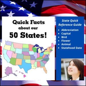
Quick reference for each state’s abbreviation, flower, bird, capital, animal & date of statehood! Please note: DO NOT PURCHASE this resource if you have already purchased 50 U.S. States | Interactive Social Studies as it is included!
-
$10.00Add to Cart
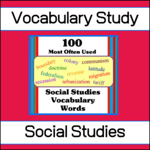
Help your students learn the 100 most often used words in Social Studies with this amazing, fun resource full of puzzles, games and worksheets. This is such an extensive resource (300+ pages) that it can be used year after year to reinforce student knowledge.
Recommended for 5th – 8th grades but would be an excellent review resource for High School students
See more details below…
-
$3.00Add to Cart
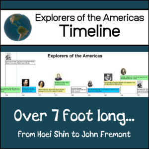
This resource will create a classroom wall timeline (over 7′ long) showing famous explorers of the Americas! The timeline begins with Hoie Shin: a Chinese monk who explored the west coast of Mexico in 499 and ends with John Fremont: nicknamed the “Pathfinder” who explored the American West in 1838. (Examples of other explorers included: Leif Ericksson, Columbus, Cabot, Cortez, Coronado, Daniel Boone, John Cook, Davy Crockett and others)
-
$8.50Add to Cart
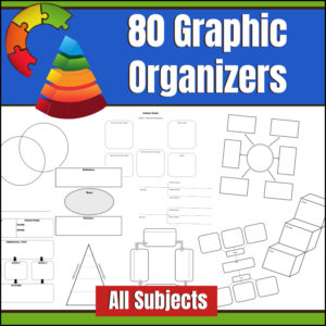
A graphic organizer, also known as knowledge map, concept map, story map, cognitive organizer, advance organizer, or concept diagram, is a communication tool that uses visual symbols to express knowledge, concepts, thoughts, or ideas, and the relationships between them. This resource gives you 80 different graphic organizers and can be used across the curriculum!
Here is a comment from a customer…
Karen E. said: “OK, at first I thought “Really? I’m going to pay for graphic organizers that I can probably find for free with some searching, etc?” Well, now I am so glad that I did. So good to have organizers available quickly BUT also several of them have variations which is helpful for “seeing” how to use them in my content area. Good value.“ -
$5.00Add to Cart
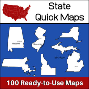
100 U.S. State outline maps – 2 maps for each state on one page:
- – Completely blank outline map
- – An outline with the state name and capital
Maps can be used for projects, bulletin boards, lesson plans and presentations.
Non-commercial use only. -
$2.00Add to Cart
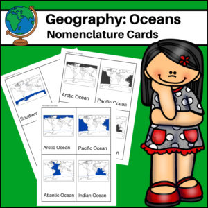
This resource, Oceans – World Geography Nomenclature Cards, will help your students learn the names and locations of the world’s 5 major oceans: Arctic, Atlantic, Pacific, Indian and Southern.
-
$3.00Add to Cart
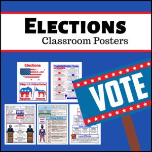
Teaching about U.S. elections? These colorful 5 election posters are packed with information about our government’s election process! Designed for 3rd, 4th, 5th and 6th grades.
Information you’ll find detailed on these posters include:
- What are our 2 major political parties
- The presidential election process (start to finish)
- Who can vote (plus when, how and where)
- Election terminology: debate, issues, platform, campaign, political party, nominate, candidate, incumbent, opponent, delegate, president, running mate, term, inauguration, oval office, ballot, citizen, democracy, election, electoral college, poll, vote
- Who are our elected officials in the U.S.? (examples of federal, state and local officials)
-
$2.00Add to Cart
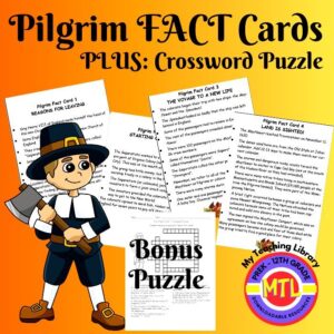
This resource gives you four Pilgrim Fact Cards:
– Reasons for Leaving
– Starting Over, Again
– The Voyage to a New Life
– Land is Sighted!Students will learn the answers to questions such as…Why did the Pilgrims leave England? Where did they move before crossing the Atlantic? What did they bring with them when coming to the New World? What is the name of the ship (not the Mayflower) that also brought pilgrims to Virginia? Why did the Wampanoag attach the colonists?
Included Bonus: A fun crossword puzzle!

&url=https://myteachinglibrary.com/product/u-s-state-map-outlines-usa-geography/&media=https://myteachinglibrary.com/wp-content/uploads/2019/08/wy-459-f.jpg)