Tag: geography
Showing 41–51 of 51 resultsSorted by latest
-
 $3.00Add to Cart
Studying the state of Maryland and state symbols? What is the state bird of Maryland?
This project-based unit is designed to help students study and record information about Maryland’s state bird: Baltimore Oriole
What type of pages are contained in this set:
– A map page (for the state)
– Scientific classification page
– A page for students to give details about the bird’s physical description, habitat, diet, life span and reproduction
– A page where students will do additional map work to show where in the U.S. the bird lives in addition to migration information
– Coloring page
– Several pages on which students can use for expository and/or creative writing as well as sections in which students may draw.14 pages in all and is designed for different levels / abilities.
My Teaching Library has a notebooking set for each of all 50 states. In addition, you can get all of them bundled!
Here are other bird related products you’ll love…
-
$2.00Add to Cart
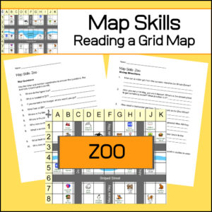
Students will practice reading a grid map and a map key with these zoo themed worksheets. Students will be given a grid map of a zoo and asked several questions requiring them read and navigate throughout the map. There are also two additional activities to extend learning (through writing and creative design). Answer Key included.
-
$5.00Add to Cart
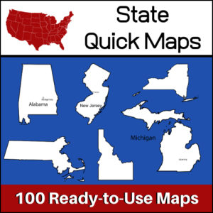
100 U.S. State outline maps – 2 maps for each state on one page:
- – Completely blank outline map
- – An outline with the state name and capital
Maps can be used for projects, bulletin boards, lesson plans and presentations.
Non-commercial use only. -
$3.00Add to Cart
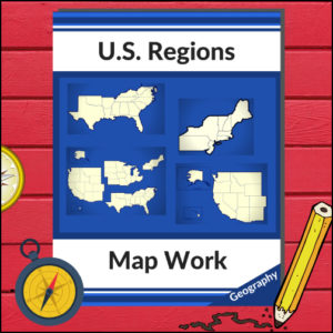
This resource will help your students learn more about U.S. Geography and the 4 main regions (as defined by the U.S. Census Bureau). Students will be working with maps of the entire United States as well as those of each region as they identify states, capitols, national parks, mountain ranges and points of interest! Great for any Social Studies class studying the U.S.A.!
-
$3.00Add to Cart
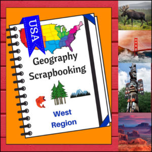
🏔️ Capture the spirit of the frontier and the beauty of the Pacific Coast with this hands-on, interactive geography resource! As your students explore the vast and varied Western region, these scrapbooking and notebooking pages provide the perfect canvas for them to document their discoveries. From the Rocky Mountains to the Hawaiian islands, students become active explorers of the American West!
This 5-page set is designed to be a flexible, creative companion to your geography curriculum, allowing students to blend factual research with their own artistic flair.
🧠 The “How” and “Why” (Educational Benefits)
Why incorporate scrapbooking into your geography lessons? It’s all about immersive learning:
- Visual & Spatial Memory: By drawing or pasting images of the West’s iconic landscapes, students create strong mental maps of diverse environments like the Mojave Desert and the Alaskan tundra. 🎨
- Summarization Skills: Writing “short sentences” about complex topics like natural resources or culture helps students practice the essential skill of synthesizing information. ✍️
- Personal Connection: The “Place I’d Like to Visit” section encourages students to connect personally with their studies, turning abstract map locations into real-life dream destinations. 💭
- Comprehensive Regional Look: These pages ensure students explore the region’s identity through six key lenses: Climate, Landforms, Water, Natural Resources, Landmarks, and Culture. 🌋🌲
🛠️ Creative Ways to Use These Pages
- Digital & Physical Integration: Have students use tablets to find authentic photos of the Grand Canyon or Yellowstone to print and paste into their scrapbooks. 📸
- A “Western Expedition” Journal: Use these pages as a project where students “travel” to a new state in the West each day, filling in their findings as they go. 🗺️
- Alternative Assessment: Use the completed scrapbooks as a portfolio piece to show mastery of the West region in a way that’s much more engaging than a traditional test.
- Interactive Notebooking: These pages fit perfectly into a social studies binder or notebook, creating a beautiful keepsake of the school year’s geographic journey. 📁
📝 What’s Included:
- 5 High-Quality Scrapbooking/Notebooking Pages: Specifically tailored to the West region.
- Guided Research Prompts: Sections for drawing, pasting, and writing about the region’s geography and lifestyle.
- State Identification: A dedicated area for naming the states within the region.
- Student Reflection: Space for students to share their personal travel interests.
Pro Tip: For the ultimate learning experience, pair these pages with Regions of the U.S. – West Region | Informational Text and Worksheets. Students can use the facts they learn there to fill their scrapbooks with expert knowledge!
🚀 Head West with Your Students! Turn your geography unit into a creative adventure! Download the West Scrapbooking Pages today and watch your students bring the wonder of the Western United States to life on the page!
⭐ This product is included in a $$$ SAVING BUNDLE: Regions of the U.S.A. | Geography Bundle
-
$4.00Add to Cart
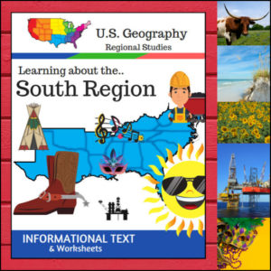
Get ready to explore the land of hospitality, diverse landscapes, and rich history! This 15-page resource offers a comprehensive, “textbook-style” deep dive into the South Region. From the sunny coasts of Florida to the rolling hills of West Virginia and the plains of Texas, your students will get a full-flavor look at what makes the South unique.
Designed to align with the U.S. Census Bureau divisions, this unit ensures your students are learning geography based on official standards.
🧠 The “How” and “Why” (Educational Benefits)
Why add this to your lesson plan? It’s designed to move students from passive readers to active thinkers:
- Priming the Brain: The Anticipation Activity forces students to think about what they think they know before they dive in, which is a proven strategy for increasing reading comprehension. 💡
- Structured Discovery: By organizing the text into six clear pillars—Land and Water, Climate, Products/Resources, Landmarks, Culture, and Food—students learn to categorize and organize complex information. 🏛️🍤
- Standardized Accuracy: This resource follows the U.S. Census Bureau regional map, including AL, AR, DE, FL, GA, KY, LA, MD, MS, NC, OK, SC, TN, TX, VA, and WV.
- Brain-Boosting Fun: The “State Name Unscramble” provides a fun cognitive break while reinforcing spelling and state recognition. 🧩
🛠️ Creative Ways to Use This Resource
- Regional Rotation Centers: Set up “The South” as one of your geography stations. Students can read the text and complete the category questions independently. 🏫
- “Travel Expert” Presentations: Assign different student pairs, (or different family members) one specific category (e.g., “Southern Food” or “Landmarks”) to read about and then present their findings. 🎤
- The Perfect Sub Folder Addition: Because it includes the informational text, worksheets, and answer keys, this is a stress-free “grab-and-go”. 🍎
- Integrated Literacy: Use the informational text during your ELA block to practice identifying main ideas and supporting details in non-fiction writing.
📝 What’s Inside This 15-Page Resource:
- Textbook-Style Informational Text: High-quality, engaging content.
- Anticipation Guide: To spark interest and check prior knowledge.
- Themed Worksheets: Dedicated question sets for every regional category.
- State Name Unscramble: A fun vocabulary-building activity.
- Full Answer Keys: For quick and easy grading! ✅
Pro Tip: To turn this into a full hands-on project, pair it with the US Geography – South Scrapbooking Pages! Students can use the facts from this text to illustrate and curate their very own Southern travel journal.
🚀 Bring the South to Your Classroom!
Stop searching for scattered facts and give your students a structured, engaging path to geographic mastery. Download the Regions of the U.S. – South Region today and start exploring! 🗺️✨
⭐ This product is included in a $$$ SAVING BUNDLE: Regions of the U.S.A. | Geography Bundle
-
$4.00Add to Cart
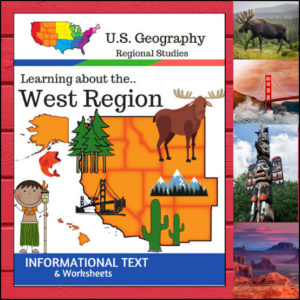
🏔️ From the volcanic peaks of Hawaii and the glaciers of Alaska to the sun-drenched deserts of the Southwest, the West Region is a land of extremes! This 15-page geography resource provides a structured, “textbook-style” exploration of the 13 states that make up this diverse region.
Following the U.S. Census Bureau regional divisions, this unit covers: Alaska, Hawaii, Washington, Oregon, California, Nevada, Idaho, Montana, Wyoming, Utah, Colorado, Arizona, and New Mexico.
🧠 The “How” and “Why” (Educational Benefits)
Why choose this unit for your geography curriculum? It’s designed to help students master complex information through high-interest content:
- Standardized & Accurate: By using the U.S. Census Bureau definitions, you ensure your students are learning the geographical groupings most commonly used in official data and advanced studies. ✅
- Holistic Exploration: We go beyond “just a map.” Students explore the region through six vital categories: Land & Water, Climate, Products & Resources, Landmarks, Culture, and Food. 🌋🍍
- Critical Thinking & Vocabulary: The category-specific questions and “State Name Unscramble” provide a mix of reading comprehension and fun cognitive puzzles. 🧩
🛠️ Ways to Use
- The Foundation of a Unit: Use the informational text as your primary reading material for a comprehensive study of the West. Its clear, concise style is perfect for independent or group/family reading. 📖
- High-Value Plans: With the text, worksheets, and full answer keys included, this is a perfect “ready-to-print” and use resource. 🍎
- Interactive Discussion: Use the “Culture and Food” sections to spark a conversation about how the West’s diverse environment influences what people eat and how they live! 🌮🏔️
📝 What’s Inside This 15-Page Resource:
- Informational Text: Detailed “textbook-style” pages on the geography and life of the West.
- Comprehensive Worksheets: Dedicated questions for every regional topic.
- State Name Unscramble: A fun way to reinforce state identification and spelling.
- Full Answer Keys: For quick, hassle-free grading. ✅
Pro Tip: For the ultimate hands-on experience, pair this unit with the US Geography – West Scrapbooking Pages! Students can use the facts they learn here to create a beautiful, illustrated travel journal of the Western states.
🚀 Adventure into the West Today!
Give your students a clear, professional, and engaging path to mastering U.S. Geography. Download the Regions of the U.S. – West Region unit and watch your young explorers discover the wonders of the American West!⭐ This product is included in a $$$ SAVING BUNDLE: Regions of the U.S.A. | Geography Bundle
-
$4.00Add to Cart
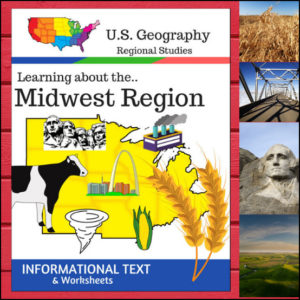
Welcome to the Heartland! This 16-page geography resource is a deep dive into the Midwest Region, providing students with a clear, “textbook-style” look at the states that power the nation’s agriculture and industry. From the Great Lakes to the Great Plains, your students will explore the unique identity of these 12 vital states.
To ensure your lessons meet official standards, this resource is designed according to the U.S. Census Bureau regional divisions, covering: Illinois, Indiana, Iowa, Kansas, Michigan, Minnesota, Missouri, Nebraska, North Dakota, Ohio, South Dakota, and Wisconsin.
🧠 The “How” and “Why” (Educational Benefits)
Why use this structured informational text approach? It builds a solid foundation for geographic literacy:
- Standardized Alignment: By following the U.S. Census Bureau definitions, you ensure your students are learning the most widely recognized regional classifications used in testing and higher education. ✅
- Comprehensive Categories: We don’t just look at a map; we dive into Land & Water, Climate, Products & Natural Resources, Landmarks, Culture, and Food. This gives students a “3D” understanding of the region. 🏗️🥧
- Built-in Assessment: The included worksheets and “State Name Unscramble” allow for immediate check-ins on student understanding without the need for extra prep.
🛠️ Ways to Use
- Main Curriculum Anchor: Use the informational text as the primary source for your Midwest unit. Its “textbook” feel makes it easy to read. 📖
- Independent Research Packets: This is a perfect “all-in-one” packet for independent study. Students can read the text and complete the questions at their own pace.
- Plans Made Simple: Since this includes the text, questions, and full answer keys, it’s a lifesaver to have for an easy, high-value geography day. 🍎
- Cross-Curricular Literacy: Use these pages during your ELA block to practice non-fiction reading skills like finding the main idea and supporting details.
📝 What’s Included:
- Textbook-Style Informational Text: Detailed sections on the geography, economy, and culture of the Midwest.
- Category-Specific Worksheets: Questions for every topic covered in the text.
- State Name Unscramble: A fun vocabulary and spelling challenge.
- Full Answer Keys: For quick, hassle-free grading! ✅
Pro Tip: To turn these facts into a beautiful keepsake, pair this unit with the US Geography – Midwest Scrapbooking Pages! Students can use the info they learn here to illustrate and write their own regional travel journals. 🎨
🚀 Explore the Heartland Today!
Give your students a structured and engaging way to look at U.S. Geography. Download the Regions of the U.S. – Midwest Region unit today and watch your students become experts on the American Midwest! 🗺️
⭐ This product is included in a $$$ SAVING BUNDLE: Regions of the U.S.A. | Geography Bundle
-
$4.50Add to Cart
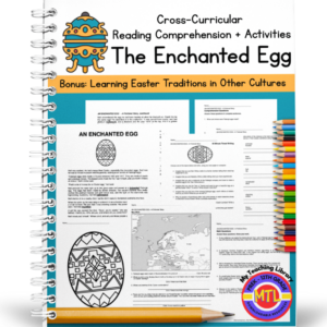
A cross-curricular (Reading/Language Arts – Math – Geography – Writing – Art) resource that students will enjoy, specifically in the Spring just before Easter. The unit begins with a fictional story called, “The Enchanted Egg” The story begins as a boy named, Neil is visiting an art museum with his parents and for the first time sees a Fabergé egg. It is a fun, delightful story as Neil ‘blacks out’ and ends up in 1910 Russia! Along the way, he learns about Easter traditions in Russia, France, Austria, Italy, Bermuda and other countries!
Includes the following activities for students to complete after reading:
1. Reading comprehension (short answer)
2. Math word problems
3. Synonyms for the following words: lightheaded, squabble, scintillate, intricate, enchanting, banquet, bejeweled, mystified, encrust, trelliswork, mourning, figurine
4. Timed writing with 9 given prompts (example prompt: Imagine that you are a craftsman at the Fabergé company and have to make a beautiful egg for the Tsar. Write about it!)
5. Story vocabulary (sentence writing)
6. Geography: Europe – map work
7. Art
8. ColoringAnswer keys provided
-
$5.00Add to Cart
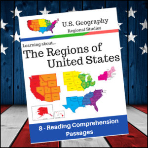
Help students expand their understanding of the different regions of the United States while learning about USA’s climate, geography, history, economy and culture.
Included sections (text and comprehension questions):
- 1. Regions of the United States
- 2. The Northeast and Midwest Regions
- 3. The South and West Regions
- 4. Learning More about the New England Subregion of the Northeast
- 5. Learning more about the Middle Atlantic Subregion of the Northeast
- 6. Learning more about the South
- 7. Learning more about the Midwest
- 8. Learning more about the West Region of the U.S
-
$2.50Add to Cart
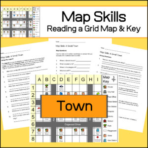
Students will be given a grid map and key of a small town and asked several questions requiring them read and navigate throughout the map. There are also two additional activities to extend learning (through writing and creative design). Answer Key included.