Category: Geography
Showing 21–40 of 54 resultsSorted by latest
-
 $5.00Add to Cart
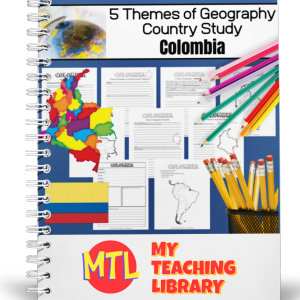
This is a country study resource on the South American country of Colombia focusing on the 5 Themes of Geography! There are a lot of country studies but this one is different.
This study will ask students to ‘think like a geographer‘ in their research and recording. Using this resource, students will…
- – Learn about the country of Colombia
- – Demonstrate knowledge of and ability to synthesize information and write about Colombia through a 5 themes of geography lens.
- – Create a wonderful project displaying their learning.
Sample questions include:
- – (Location) Describe the relative location of the country.
- – (Location) What is the latitude and longitude of the capital city?
- – (Place) What major landforms are found in the country?
- – (Place) What is/are the climate type(s) of the country?
- – (Regions) When considering this country, describe and give examples of at least one type of functional region within it.
- – (Movement) Describe any historically important migration patterns of information you have found about past or current migration for this country. You may include internal, external migration, emigration, immigration, return and/or seasonal migration.
- – (Human/Environmental Integration) Give examples of how people who have lived in this country chanted or modified the environment.
There are many more questions and this unit is designed to get your students thinking like a geographer!!
-
$5.00Add to Cart
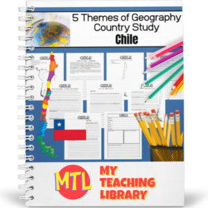
This is a country study resource on the South American country of Chile focusing on the 5 Themes of Geography! There are a lot of country studies but this one is different.
This study will ask students to ‘think like a geographer‘ in their research and recording. Using this resource, students will…
- – Learn about the country of Chile
- – Demonstrate knowledge of and ability to synthesize information and write about Chile through a 5 themes of geography lens.
- – Create a wonderful project displaying their learning.
Sample questions include:
- – (Location) Describe the relative location of the country.
- – (Location) What is the latitude and longitude of the capital city?
- – (Place) What major landforms are found in the country?
- – (Place) What is/are the climate type(s) of the country?
- – (Regions) When considering this country, describe and give examples of at least one type of functional region within it.
- – (Movement) Describe any historically important migration patterns of information you have found about past or current migration for this country. You may include internal, external migration, emigration, immigration, return and/or seasonal migration.
- (Human/Environmental Integration) Give examples of how people who have lived in this country changed or modified the environment.
There are many more questions and this unit is designed to get your students thinking like a geographer!!
Students will need to have a good understanding of the 5 Themes of Geography to complete this project. Need teaching materials for the 5 Themes? Get My Teaching Library’s 5 Themes of Geography Bundle
-
$5.00Add to Cart
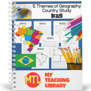
This is a country study resource on the South American country of Brazil focusing on the 5 Themes of Geography! There are a lot of country studies but this one is different.
This study will ask students to ‘think like a geographer‘ in their research and recording. Using this resource, students will…
- – Learn about the country of Brazil
- – Demonstrate knowledge of and ability to synthesize information and write about Brazil through a 5 themes of geography lens.
- – Create a wonderful project displaying their learning.
Sample questions include:
- – (Location) Describe the relative location of the country.
- – (Location) What is the latitude and longitude of the capital city?
- – (Place) What major landforms are found in the country?
- – (Place) What is/are the climate type(s) of the country?
- – (Regions) When considering this country, describe and give examples of at least one type of functional region within it.
- – (Movement) Describe any historically important migration patterns of information you have found about past or current migration for this country. You may include internal, external migration, emigration, immigration, return and/or seasonal migration.
- (Human/Environmental Integration) Give examples of how people who have lived in this country changed or modified the environment.
There are many more questions and this unit is designed to get your students thinking like a geographer!!
Students will need to have a good understanding of the 5 Themes of Geography to complete this project. Need teaching materials for the 5 Themes? Get My Teaching Library’s 5 Themes of Geography Bundle
-
$5.00Add to Cart
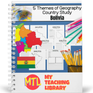
This is a country study resource on South American country of Bolivia focusing on the 5 Themes of Geography! There are a lot of country studies but this one is different.
This study will ask students to ‘think like a geographer‘ in their research and recording. Using this resource, students will…
- – Learn about the country of Bolivia
- – Demonstrate knowledge of and ability to synthesize information and write about Bolivia through a 5 themes of geography lens.
- – Create a wonderful project displaying their learning.
Sample questions include:
- – (Location) Describe the relative location of the country.
- – (Location) What is the latitude and longitude of the capital city?
- – (Place) What major landforms are found in the country?
- – (Place) What is/are the climate type(s) of the country?
- – (Regions) When considering this country, describe and give examples of at least one type of functional region within it.
- – (Movement) Describe any historically important migration patterns of information you have found about past or current migration for this country. You may include internal, external migration, emigration, immigration, return and/or seasonal migration.
- (Human/Environmental Integration) Give examples of how people who have lived in this country changed or modified the environment.
There are many more questions and this unit is designed to get your students thinking like a geographer!!
Students will need to have a good understanding of the 5 Themes of Geography to complete this project. Need teaching materials for the 5 Themes? Get My Teaching Library’s 5 Themes of Geography Bundle
-
$5.00Add to Cart
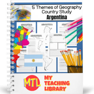
This is a project-based notebooking country study resource with a focus on the 5 Themes of Geography. There are a lot of country studies but this one is different!
This study will ask students to ‘think like a geographer‘ in their research and recording. By the end of the study, students will have learned about the country, their knowledge of the 5 themes will have been reinforced and they will have created a wonderful project displaying their learning.
Using this resource, students will…
- Learn about the country of Argentina
- Demonstrate knowledge of and ability to synthesize information and write about Argentina through a 5 themes of geography lens.
- Create a wonderful project displaying their learning.
Sample questions include:
- – (Location) Describe the relative location of the country.
- – (Location) What is the latitude and longitude of the capital city?
- – (Place) What major landforms are found in the country?
- – (Place) What is/are the climate type(s) of the country?
- – (Regions) When considering this country, describe and give examples of at least one type of functional region within it.
- – (Movement) Describe any historically important migration patterns of information you have found about past or current migration for this country. You may include internal, external migration, emigration, immigration, return and/or seasonal migration.
- (Human/Environmental Integration) Give examples of how people who have lived in this country changed or modified the environment.
There are many more questions and this unit is designed to get your students thinking like a geographer!!
Students will need to have a good understanding of the 5 Themes of Geography to complete this project. Need teaching materials for the 5 Themes? Get My Teaching Library’s 5 Themes of Geography Bundle
-
Sale!Original price was: $22.75.$18.75Current price is: $18.75.Add to Cart
🌎Are you tired of piecewise planning? Stop searching for separate resources and equip your students with a complete, mastering understanding of the world with: Understanding the 5 Themes of Geography: Complete Curriculum Bundle
This bundle is your one-stop shop for teaching the fundamental pillars of human and physical geography. By combining deeply researched informational text with engaging, no-prep activities, this curriculum transforms abstract concepts into clear, real-world connections. Stop just “telling” students about the world and help them analyze it like professional geographers.
📦 What’s Included in this BUNDLE?
This comprehensive bundle includes all five of our deeply-focused units, covering every essential theme:
- LOCATION: Absolute vs. Relative, Latitude, Longitude, & Hemispheres. (Teach the grid and the global address system).
- PLACE: Physical vs. Human Characteristics. (Explore what makes every location unique).
- HUMAN/ENVIRONMENT INTERACTION: Adaptation, Modification, & Community Impacts. (Analyze the dynamic relationship between people and their surroundings, including specific deforestation and pollution vocabulary).
- MOVEMENT: Migration (Push/Pull factors), Trade, & Globalization. (Investigate the flow of people, goods, and ideas).
- REGION: Formal, Functional, & Perceptual Regions. (Discover how geographers categorize and organize the Earth’s surface).
✨ Benefits (Why This Bundle Works)
- ✅ NO PREP! Every single unit in this bundle is print-and-go. Save dozens of planning hours and get directly to teaching.
- ✅ Comprehensive Deep Dives: This isn’t a shallow overview. Every theme gets its own in-depth exploration, taking students far beyond basic definitions.
- ✅ Active Learning & Variety: Students won’t just sit and read. Activities range from crosswords and vocab matching to complex mapping exercises and a community interview project.
- ✅ Robust Vocabulary: Includes all five full vocabulary sets, complete with matching visual cards for word walls or stations.
- ✅ Standards Aligned: Built to support middle and high school social studies and AP Human Geography foundational standards.
🧠 Specific Components (Inside Every Unit)
Each individual unit features a consistent, high-quality structure:
- Multiple pages of deeply researched Informational Text. 📖
- A complete set of printable Vocabulary Cards with visual cues. 🗂️
- Multiple Student Worksheets (mapping, graphic organizers, short answer, critical thinking). ✍️
- Specific review tools, such as Crossword Puzzles. 🧩
- Unique culminating activities, like the Interview Assignment in the Human/Environment unit. 🎤
- Full Answer Keys for every single worksheet and puzzle. ✅
🚀 Equip Your Students to Define Their World!
Stop piecewise planning and start building geographic literacy. Master the foundational pillars that make understanding our complex world possible.
Add to Cart / Download Now and get the complete, mastering solution for the 5 Themes of Geography today! 🌏✨
After using this product, students will have the knowledge and understanding to use our full-year notebooking bundle: 5 Themes of Geography | North and South America
-
$4.50Add to Cart
🌍 How do we group the world together? While Location and Place describe specific points, Region is the geographic theme that allows us to see the “big picture.” This comprehensive unit provides an in-depth exploration of how geographers organize the Earth’s surface into manageable pieces based on shared traits. 🗺️🤝
This resource breaks down the complex ways areas are defined, teaching students to look beyond borders to find the Physical, Human, and Cultural threads that tie a region together.
📦 What’s Included in This Resource?
- 5 Pages of Informational Text: Detailed, student-friendly reading passages that explain how regions are formed and why they matter. 📖
- Vocabulary Cards: Essential terms ready for your word wall, pocket charts, or interactive notebooks. 🗂️
- 5 Student Worksheet Pages: High-interest activities designed to help students identify and categorize different region types. ✍️
- Full Answer Keys: Quick and easy grading! ✅
🧠 Vocabulary Mastered in This Unit
Your students will become experts in the “Language of Geography,” focusing on:
- The Core Concept: Region, Unifying Characteristics.
- The Three Characteristics: Human, Physical, and Cultural.
- The Three Region Types: Formal, Functional, and Perceptual (Vernacular).
✨ Educational Benefits
- Categorical Thinking: Students learn to identify unifying characteristics, helping them understand how massive amounts of geographic data are organized. 📊
- Abstract Reasoning: By learning about Perceptual Regions, students explore how human feelings and attitudes (like “The South” or “The Midwest”) shape our view of the world.
- Global Perspective: This unit encourages students to see connections between people and environments that go beyond simple political boundaries.
- Curriculum Alignment: Perfect for middle and high school social studies, world geography, or AP Human Geography introductory units.
🛠️ How to Use This Unit
- Direct Instruction: Use the informational text pages as the primary source for your lecture or guided reading session.
- Concept Sorting: Use the vocabulary cards for a “Sort and Predict” activity—have students guess which characteristics belong to which region type. 🃏
- Mapping Practice: Pair the worksheets with a classroom atlas. Have students find real-world examples of a Functional Region (like a subway system) or a Formal Region (like a country).
- Discussion Starters: Use the concept of Perceptual Regions to spark a debate: Where exactly does “The North” end and “The South” begin? 🗣️
- Assessment or Review: Use the worksheet pages as a comprehensive end-of-unit assessment or as a rigorous review before a geography exam.
🚀 Organize the World!
Stop seeing the world as just a collection of random spots and start seeing the patterns that connect us all. Give your students the analytical tools to categorize the globe like a professional geographer.
Add to Cart / Download Now and take a deep dive into the 5 Themes of Geography: Region today! 🌏✨
-
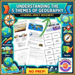
$4.75Add to Cart🌍 Geography is about more than just dots on a map, it’s about the flow of life across the globe! While there are 5 major themes of geography (Location, Place, Human/Environment Interaction, Movement, and Regions), this unit provides a comprehensive exploration of Movement. ✈️📦📱In this deep dive, students will investigate how people, goods, and ideas travel from one place to another. This resource tackles complex topics like the “why” behind migration, the mechanics of global trade, and how the digital age has revolutionized the spread of information and globalization.📦 What’s Included in This Resource?
-
5 Pages of Informational Text: Detailed reading passages covering why people move, types of migration, trade, and the evolution of ideas. 📖
-
Vocabulary Cards: Ready-to-print cards for word walls, flashcards, or geography stations. 🗂️
-
5 Student Worksheet Pages: High-interest activities to reinforce concepts of push/pull factors and trade. ✍️
-
1 Crossword Puzzle: A fun, engaging way to review key terminology! 🧩
-
Full Answer Keys: Designed to make your grading quick and easy. ✅
🧠 Vocabulary Mastered in This UnitStudents will become fluent in the essential language of human geography:-
The Big Move: Migration (Internal, External, Return, Seasonal).
-
The Motivators: Push Factors and Pull Factors.
-
The People: Emigrant, Immigrant, and Refugee.
-
Global Trade: Imported Goods, Exported Goods, and Globalization.
✨ Educational Benefits-
Understanding Human Systems: Students gain a deep understanding of why people migrate and the difference between internal and external movement.
-
Economic Literacy: By learning about imports and exports, students begin to understand the basics of the global economy. 💰
-
Critical Thinking: Analyzing how the movement of ideas has changed over time helps students reflect on the impact of technology and globalization.
-
Standard-Aligned Content: Perfectly tailored for middle school social studies and world geography curriculum.
🛠️ How to Use This Unit-
Guided Reading: Use the 5 pages of informational text for individual instruction, whole-class instruction or as a close-reading activity in small groups.
-
Vocabulary Stations: Use the vocabulary cards for “Match-Up” games or as a reference for students during writing assignments. 🃏
-
Graphic Organizers: Have students use the worksheets to map out the “Push and Pull” factors for different types of migration discussed in the text.
-
Enrichment: The crossword puzzle is the perfect tool for students who finish their work early or as a fun review game. 🧩
-
Ready to Use: With clear text and answer keys provided, this unit is a reliable “print and go” resource for any situation. 🍎
🚀 Get the World Moving!Equip your students with the knowledge to understand how our world stays connected. From ancient trade routes to modern-day globalization, help them see the patterns that define our existence.Add to Cart / Download Now and start your deep dive into Movement today! 🌏✨ -
-
Add to CartUnderstanding the 5 Themes of Geography: Social Studies Deep Dive into Human Environment Interaction$4.50
🌍 How do we shape the world, and how does the world shape us? While there are 5 major themes of geography (Location, Place, Human/Environment Interaction, Movement, and Regions), this unit provides a focused exploration of the dynamic relationship between people and their surroundings. 🏗️🌱
This resource helps students understand that geography isn’t just about maps—it’s about how humans adapt to, depend on, and modify the environment to survive and thrive. From the clothes we wear to the way we change the landscape, this unit covers it all!
📦 What’s Included in This Resource?
- 3 Pages of Instructional Text: Engaging reading material that explains the core concepts of human-environment relationships. 📖
- Vocabulary Cards: Perfect for visual learners, word walls, or quick-fire review sessions. 🗂️
- 8 Student Worksheet Pages: A variety of activities to reinforce learning and ensure concept mastery. ✍️
- Special Interview Assignment: A unique project that encourages students to connect geography to real-life experiences in their community. 🎤
- Full Answer Keys: Designed to save you time and make grading effortless. ✅
🧠 Vocabulary Mastered in This Unit
Students will dive deep into the essential terms that define our impact on the planet:
- The Big Ideas: Adaptation, Modification.
- Environmental Impact: Deforestation, Desertification, and Pollution.
✨ Educational Benefits
- Critical Thinking: Students analyze how human choices—like farming or urban development—directly impact the physical world. 🚜
- Real-World Connections: By exploring topics like pollution and deforestation, students connect classroom learning to current global issues. 🌎
- Active Learning: The included interview assignment moves students beyond the textbook, encouraging them to see geography in action within their own families or neighborhoods.
- Standards Alignment: Built to support middle school social studies and geography standards focusing on human systems and environmental change.
🛠️ How to Use This Unit
- Guided Discovery: Start with the 3 pages of instructional text to establish a solid foundation of how humans interact with nature.
- Vocabulary Builders: Use the cards for a “Think-Pair-Share” activity where students define terms using real-world examples. 🃏
- The “Change the World” Project: Assign the Interview Assignment as a weekend project to help students see how local environments have changed over generations.
- In-Depth Practice: Utilize the 8 worksheet pages for independent work, small group rotations, or as a comprehensive study guide.
- Assessment Ready: Use the worksheets as a formative assessment to check for understanding before moving on to the next theme. 🍎
🚀 Bridge the Gap Between Nature and People!
Don’t just teach geography—teach the story of human survival and innovation. Empower your students to understand their role in the environment and the footprints we leave behind.
Add to Cart / Download Now and start your deep dive into Human/Environment Interaction today! 🌏✨
-
$4.50Add to Cart
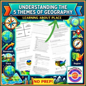
🌍 What makes a location unique? While Location tells us where something is, Place tells us what it’s actually like when you get there. This comprehensive unit focuses exclusively on the second pillar of geography, helping students distinguish between the natural world and the marks humans leave behind. 🏔️🏙️
This resource dives deep into the “personality” of a location, breaking down the complex layers of Physical and Human characteristics that define our world.
📦 What’s Included in This Resource?
- 8 Pages of Instructional Text: Detailed, student-friendly reading passages that explain the nuances of physical vs. human traits. 📖
- Vocabulary Cards: Ready-to-use cards for word walls, matching games, or study aids. 🗂️
- 4 Student Worksheet Pages: Engaging activities to reinforce the difference between biomes, landforms, and cultural systems. ✍️
- Critical Thinking Essay Questions: Prompts designed for deep reflection, perfect for class discussions or formal assessments. 🧠
- Full Answer Keys: Streamline your grading process! ✅
🧠 Vocabulary Covered
Students will master a robust set of geographic terms, including:
- The Big Two: Physical Characteristics & Human Characteristics.
- Physical World: Landforms, Soil, Humus, Vegetation Regions, Life Zones, and Biomes.
- Climate Zones: Tropical, Dry, Temperate, Continental, Polar, Mild, and High Elevation.
✨ Educational Benefits
- Categorical Thinking: Students learn to classify information into “Physical” (natural) and “Human” (cultural) categories, a foundational skill for higher-level social studies.
- Climate Literacy: Includes a detailed look at global climate types, helping students understand why certain regions look and feel the way they do. 🌦️
- Cultural Awareness: By examining architecture, religion, and political systems, students gain a better appreciation for global diversity.
- Literacy Integration: The text provide excellent opportunities for “reading across the curriculum” and improving informational text comprehension.
🛠️ How to Use This Unit
- The “Personality” Intro: Use the instructional text to introduce “Place” as the personality of a location. Have students describe the physical and human traits of their own hometown.
- Climate Sorting: Use the vocabulary cards to have students sort the different climate types (e.g., Polar vs. Tropical) and discuss the vegetation that grows in each.
- Graphic Organizers: Have students use the worksheets to compare two different “Places” (like a desert biome vs. a temperate forest) using the physical characteristics taught in the unit.
🚀 Define Your World!
Stop just “locating” things on a map and start understanding what makes them special. Give your students the tools to analyze the world around them through the lens of geography.
Add to Cart / Download Now…and start your deep dive into Place today! 🌏✨
-
$4.50Add to Cart
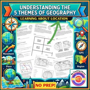
🌍 Help your students navigate the world and understand geography with confidence! While there are 5 major themes of geography (Location, Place, Human/Environment Interaction, Movement, and Regions), this comprehensive unit provides a deep dive into the very first pillar: Location. 📍
This resource simplifies complex spatial concepts, teaching students how to identify exactly where they are on Earth using both Absolute and Relative location. From mastering the grid system of latitude and longitude to visualizing the world’s hemispheres, this unit is your “one-stop shop” for foundational geography skills.
📦 What’s Included in This Resource?
- 5 Pages of Instructional Text: Engaging, easy-to-read content that breaks down the 5 themes and focuses heavily on the mechanics of Location. 📖
- Comprehensive Vocabulary Cards: Perfect for word walls or flashcard study. 🗂️
- 5 Student Worksheet Pages: High-interest activities to reinforce latitude/longitude skills and hemispheric orientation. ✍️
- Full Answer Keys: Make grading a breeze! ✅
🧠 Vocabulary Covered
This unit ensures students master the essential “language of geography”:
- The Grid: Lines of Latitude, Lines of Longitude, Parallel, Meridian.
- The Dividers: Equator, Prime Meridian.
- The Four Hemispheres: Northern, Southern, Eastern, and Western.
- The Core Concept: Absolute Location vs. Relative Location.
✨ Educational Benefits
- Spatial Awareness: Students develop a mental map of the world and understand the mathematical precision of global positioning. 🗺️
- Critical Thinking: By comparing absolute and relative location, students learn to describe the world using both data and context.
- Standard-Aligned: Supports key Social Studies and Geography standards regarding map skills and Earth’s physical systems.
- Versatility: Designed to bridge the gap between upper elementary and middle school geography curriculum. Appropriate for high school students as well who have not mastered the themes of geography or need a refresher.
🛠️ How to Use This Unit
- Direct Instruction: Use the 5 pages of instructional text as a guided reading activity or as the basis for your classroom lectures.
- Vocabulary Warm-ups: Use the included cards for “Bell Ringer” activities or matching games to build academic language. 🃏
- Independent Practice: Assign the 5 worksheet pages for interactive notebook entries, homework, or assessments.
- Geography Stations: Rotate students through stations focusing on different hemispheres or coordinate plotting using the worksheets.
- Ready-to-Use: With clear text and answer keys provided, this is a perfect “print and go” resource! 🍎
🚀 Ready to Plot Your Course?
Equip your students with the tools they need to decode the globe. Stop the “where are we?” confusion and start building real-world map mastery today!
Add to Cart / Download Now to start a deep dive into the 5 Themes of Geography.
-
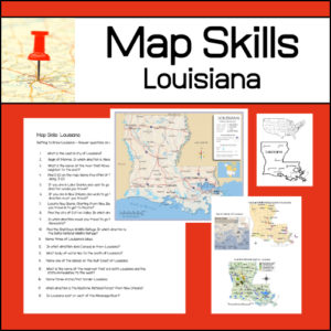
$1.50Add to Cart
Learning to read different types of maps is a vital skill for students to learn and practice. With this resource, students will be given several maps and questions to answer using the maps. Maps and questions all center around the state of Louisiana.
-
$6.00Add to Cart
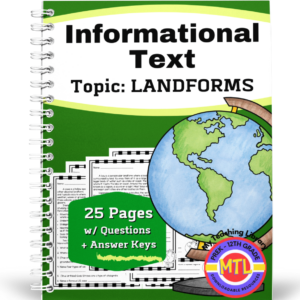
Whether you are simply looking for informational text resources or you are studying landforms, if your teaching grades 5th-8th, this resource is perfect! The resource includes 25 reading pages with questions about a given landform. Questions include both short answer and true/false.
Flesch-Kincaid levels range from 5.5 – 8.3
These are short reading passages with 5 – 7 questions after each.
-
$1.25Add to Cart
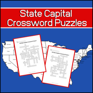
Studying the capitals of the United States? Want a couple fun, educational crossword puzzles for your students? Here they are!
Includes: 2 Crossword puzzles.
Each puzzle comes with 2 ‘clue’ pages. One without possible answers and one with a word bank from which to choose. You decide which one to give students!Answer keys provided.
-
$3.00Add to Cart
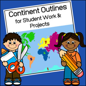
This resource, Continent Outlines for Student Work and Projects, contains 14 pages of continent outlines (7 labeled, 7 unlabeled). This is not clipart but ready to use outlines, just print and give to students to use however they need to!
-
$3.00Add to Cart
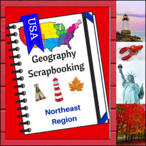
Turn your geography lessons into a creative travel adventure! As your students explore the historic and diverse Northeast region, these scrapbooking pages offer a dynamic way for them to document their “journey.” Instead of just memorizing facts, students become curators of their own learning, capturing the essence of the states from Maine down to Pennsylvania.
This 5-page set is designed to be the perfect companion to your regional studies, allowing students to blend artistic expression with factual writing.
🧠 The “How” and “Why” (Educational Benefits)
Why swap traditional worksheets for scrapbooking? It’s all about active synthesis:
- Multisensory Engagement: By drawing or pasting pictures and writing short descriptions, students engage multiple areas of the brain, leading to significantly higher information retention. 🎨
- Critical Thinking & Opinion: The “Personal Opinion” section moves beyond rote memorization, asking students to evaluate information and decide what interests them most—a key skill in developing independent learners. 💭
- Comprehensive Coverage: These pages guide students through the “Big Six” of geography: Climate, Landforms, Water, Natural Resources, Landmarks, and Culture. 🏔️🌊
- Ownership of Learning: Creating a scrapbook gives students a sense of pride and ownership. It’s no longer just a school assignment; it’s an artifact of their hard work. 📖
🛠️ Creative Ways to Use These Pages
- The “Travel Journal” Project: Have students “visit” the Northeast virtually. Use these pages as their daily log to record what they “saw” each day. ✈️
- State Fair Displays: If students are doing a deep dive into specific states, use these pages as the centerpiece for a poster board or display table.
- Geography Portfolios: Add these pages to a year-long geography binder. By the end of the year, students will have a complete “Travel Guide to the USA.” 📁
- Collaborative Posters: Print the pages at a larger scale and have small groups (or family) work together to illustrate and describe a specific aspect of the Northeast (like “Culture and Food”). 🍕
📝 What’s Included:
- 5 Detailed Scrapbooking Pages: Focused on the Northeast states.
- Guided Categories: Sections for Climate, Landforms, Water, Natural Resources, Landmarks, and Culture.
- Map Skills: Locating the states within the region.
- Personal Reflection: Space for students to share where they would most like to visit.
Pro Tip: This set is designed to pair perfectly with My Teaching Library’s Regions of the U.S. – Northeast Region | Informational Text and Worksheets for a complete, no-prep curriculum solution!
🚀 Start Your Northeast Adventure!
Transform your geography unit from dry facts into a vivid discovery! Download the Northeast Scrapbooking Pages today and give your students the creative space to show off what they know!✨
⭐ This product is included in a $$$ SAVING BUNDLE: Regions of the U.S.A. | Geography Bundle
-
$4.00Add to Cart
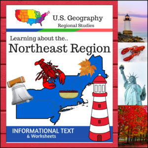
Take your students on a journey through the historic and rugged Northeast Region! This 12-page resource provides a comprehensive “textbook-style” experience without the bulk of a heavy manual. From the Appalachian Mountains to the bustling Atlantic harbors, students will explore the unique identity of this vital corner of the United States.
This resource is designed to be a “one-stop shop” for regional literacy, covering Land and Water, Climate, Products and Natural Resources, Landmarks, Culture, and Food.
🧠 The “How” and “Why” (Educational Benefits)
Why choose this informational text set? It’s built on proven instructional strategies:
- Activates Prior Knowledge: The Anticipation Activity primes the brain for learning, helping students make connections between what they think they know and the new facts they are about to discover. 💡
- Targeted Comprehension: By breaking the text into specific categories (like Climate or Culture), students learn how to scan for information and master the art of non-fiction reading. 📖
- Critical Thinking: The category-specific questions require students to synthesize the text rather than just skimming for a single word.
- Skill Reinforcement: The “State Name Unscramble” provides a fun, low-stakes way to reinforce spelling and geographical recognition of the Northeast states. 🧩
🛠️ Ways to Use This in Your Classroom
- The Foundation of a Unit: Use the informational text as your primary reading material for a week-long deep dive into the Northeast.
- Guided Reading Groups: Break into small groups, assign each group one category (like “Landmarks” or “Food”) to read and present back to the class. If homeschooling, this can be done as a family. 🏫
- Create an Independent Research Station: Place the worksheets in a center or folder for students to complete at their own pace.
- Easy Plans: With clear text, structured questions, and included answer keys, this is the perfect “grab-and-go” resource. 🍎
📝 What’s Inside This 12-Page Resource:
- Textbook-Style Informational Text: High-quality content covering all major regional pillars.
- Anticipation Activity: Get those gears turning before the reading begins!
- Comprehensive Student Worksheets: Detailed questions for every category.
- State Name Unscramble: A fun challenge to wrap up the unit.
- Full Answer Keys: For quick, easy grading. ✅
Pro Tip: For the ultimate hands-on experience, pair this resource with the US Geography – Northeast Scrapbooking Pages! Students can use the facts they learn here to create their own beautiful regional journals.
🚀 Ready to Explore the Northeast?
Give your students a clear, structured, and engaging way to master U.S. Geography.Add the Regions of the U.S. – Northeast Region to your curriculum today and start the adventure!
⭐ This product is included in a $$$ SAVING BUNDLE: Regions of the U.S.A. | Geography Bundle
-
 $8.00Add to Cart
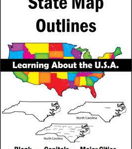
150 maps included in this download!
Each state has 3 pages / maps:
* Outline of the state
* Map showing the capital
* Map showing the major cities -
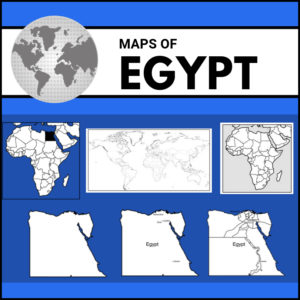
$8.75Add to Cart
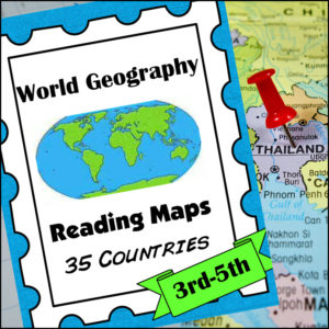
A comprehensive map-reading resource designed to help students develop essential navigation and analytical skills by focusing on 35 different countries.
Key Features:
-
Country-Specific Focus: For each country, students are given a map and asked specific questions that will require them to read the map to answer. (Questions may be things such as the location of the capital, naming rivers that are within or border the country, mountain ranges within the country, what nations border the country, etc.)
-
Critical Thinking Exercises: The worksheets go beyond simple identification, prompting students to solve navigation problems, determine cardinal directions, and estimate distances between major cities.
-
Integrated Learning: The resource connects physical geography with logical reasoning, helping students understand how environmental features like mountain ranges and bodies of water shape national landscapes and travel routes.
-
Ready-to-Use Answer Keys: The included answer keys make this an efficient tool for independent study, homeschooling, or classroom assessment.
Countries included: Algeria. Antarctica. Argentina. Australia. Bolivia. Brazil. Canada. Chile. China. Colombia. Ecuador. Egypt. Ethiopia. France. Ghana. Greece. Spain/Portugal. India. Iran. Iraq. Ireland. Italy, Japan, Kenya, Liberia, Libya, Madagascar, Mexico, Morocco, Nigeria, Peru, Russia, Saudi Arabia, South Africa, Uganda
This resource is an ideal addition to any social studies program, providing the structure needed for students to build confidence in reading maps and understanding global geography.
-


&url=https://myteachinglibrary.com/product/u-s-state-map-outlines-usa-geography/&media=https://myteachinglibrary.com/wp-content/uploads/2019/08/wy-459-f.jpg)